
|
|
Description of Dukinfield circa 1830
The Village
Saxton’s Map of Cheshire 1577 shows Ashton as the only township to the east of Manchester and Stockport. Dukinfield is tiny village with two small settlements at Old Hall and Hall Green. The other areas on the map were merely hamlets; Mottram, Stalyhal, Matley and Denton chapel. Most of Dukinfield was thickly wooded with clearances at the lower levels for agriculture. These were still feudal times and conditions will have been very similar to those appertaining in the Custom Roll and Rental of Assheton Manor 1422. The only link between Ashton and Dukinfield was a small ancient bridge at Whitelands.
In the middle of the eighteenth century there were fewer than 1,000 people living in Dukinfield, which then covered a much larger area. All the parts of Stalybridge south of the river Tame on the Cheshire side then came within the Dukinfield boundary. Apart from a few more houses and workshops built towards the end of the eighteenth century the village was still then, in essence what it had been in the 1740’s. The main settlement was then centred on Chapel Hill with a smaller community near Old Hall near the river. In front of Old Chapel ran the only real road leading to Ashton via Old Road and to Newton via Birch Lane. The only other road of any importance was Dog Lane (now Astley Street) via Chapel Street to the Old Hall area. The area around Old Hall was a beautiful wooded park with an avenue of trees. The outskirts of the park were well cultivated, and a number of tenants and retainers were housed in cottages encircling the open space caled 'The Green'. Early in the nineteenth century there was a large hat factory belonging to Mr Hadfield on Dewsnap Lane. Hatting, prior to industrialisation, had for a long time been a cottage industry and used by many to supplement their farming income. At Yew Tree there was an old farm named after the huge old yew that grew beside it. Next to the farm was an old barn, probably the oldest building in Dukinfield and a likely candidate to be the one where Samuel Angier held his services, during the persecutions of Charles II. Further up this road on the left stands Hunters Tower, built by Mr Francis Dukinfield Astley in 1807. Behind this again is Early Bank Wood and Hough Hill overlooking Stalybridge.
Another road led via Pickford lane to the Lakes built more than a hundred years ago, then a very prettily set out residence set out with shrubberies enclosing a small lake. King Street was then a country lane leading from Kingston to some stepping-stones across the river Tame, through a plantation of tall trees. These stepping-stones were the only way of crossing the Tame at this part of the river until Alma Bridge was built in 1855. Park Road was then little more than a bridle path leading to the Lord of the Manor’s corn grinding mill.
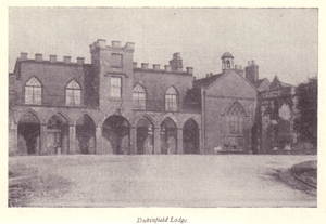
Hall Green as mentioned before was the Village Green with wooden stumps linked by chains. From here Old Road took a windy path down to the bridge built by John Astley across the Tame to Ashton. Dukinfield Old Chapel occupied a large open space on Chapel Hill. The Astley Arms next door was built by John Astley.The Lodge, just below Hall Green (see illustration below), was the new home of the Lords of the Manor. Here, John Astley, the painter and more especially his son, 'the Squire,' lived in great style. The Lodge Park is now the site of Dukinfield Cemetery and Crematorium.
Leading to Town Lane was the Circus, a handsome round block of houses with lawns in front and the road running through. They were built by Squire Astley at the end of the eighteenth century, based on a design he had seen in London. The grand design has now been sadly spoilt by new roads having been cut through. The end house was once kept by the well-known Nancy Spragg and her mother as a druggist's shop. They were very expert at drawing teeth and doctoring burns, scalds, sores and other minor ailments. At the house on the other end, next to the Astley Arms, was Whittaker's shoemaker's shop commonly called "The Parliament House," where gathered the local politicians to discuss world affairs. Doctor Booth had his surgery in the Circus, and other well-known residents were Mr Jonathan Newall and the Nadins.
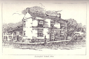
Fron the Circus , or Half Moon and Crescent as the east and west sides came to be known, wound down the hill on the south side the zig-zag Town Lane. It contained a good number of cottages and small shops with small-paned windows. Where Price Street is now were three old houses, once a farm. The middle house had a stone in the front wall with the figures 1632, probably marking the date of the erection of the farm house. Of the houses taken down in Pickford Lane to make room for the extension of the "Big School," two were very old an had the date 1635 on the walls (see picture below). Opposite to the school where Mr Walker's timber yard is there used to be a farm which stood well out into the roadway and formed an acute angle to the street. There was a date of 1749 containing some initials in the wall by the front gate. At one time it was kept by a family called Stanley and the yard was called Stanley's Fold, or, in the vernacular "Stanley's Fowt." T A Coward accounts for the frequency of the word "Fold" in this neighbourhood from the necessity the farmers formerley had of enclosing their chattels in strongly fenced pens to preserve them from the attacks of marauders from the northern side of the Tame. Pickford Lane descended the hill to the road leading to the Lakes, and from the junction a field path crossed the meadow to King Street. Another path, almost identical to the present one, went from Stanley's farm to the Lakes Pit.
Near to the corner of Pickford Lane was the "lock-up," a small, strongly built block, constructed of thick layers of dressed stone. It is said to have been used only once, as it was too damp and cold. Another lock-up was situated near Hall Green. Before the establishment of the Local Board, the government of the village was partly entrusted to four constables, nominated by the ratepayers and appointed by the Court Leet for the Macclesfield Hundred, and partly to a constable appointed by the magistrates of the Hyde division. The magisterial constable received a salary of fifty pounds per annum, and acted for both Dukinfield and Newton. One of the first constables for the village was Uriah Chadwick, who was also a member of the Astley Yeomanry. Others whose names are remembered were Joseph Hollingworth, afterwards a grocer in Wellington Street; Frank Kemp, a carrier, who kept the Newmarket Tavern in King Street and Benny Hague, the schoolmaster. Victoria Street, off Town, was called, for some unremembered reason, "Wonderful Corner."
Further towards Ashton along Astley Street is Plantation farm. This was the birthplace of Mary Moffat (nee Smith) the famous African Missionary. Around the turn of the eighteenth century Plantation Farm or Dukinfield Nurseries, as it was known, was a very large concern with parts of its grounds extending almost to Guide Bridge. Here John Smith had a prosperous nursery garden. His daughter Mary was born in 1795. She was educated at Fairfield Moravians and longed for missionary work overseas. She fell in love with Robert Moffat, a young Scotsman, who came to work for her father. He also had a burning ambition for missionary work in Africa. Robert set sail for Africa in 1816 and after 3 years breaking down her family’s objections, she travelled to Capetown in 1819, where they were immediately married.
They only returned to England once from 1839-1843 where Robert addressed enthusiastic meetings all over the country. At one meeting was a young David Livingstone who later stayed for a while with the Moffats at Kuruman where he married Mary Moffat’s eldest daughter Mary much to he mother’s disapproval.
Amidst this description of the village idyll were stirrings at the turn of the century. Family industries (Hatting, weaving and spinning etc) were due for tumultuous change. The advent of mechanisation was anticipated by some, who would go on to make their fortunes, whilst the less enterprising were to become slaves to “King Cotton”.
| Home | Contents | Local Links | Useful Addresses | Family History Links | Forum | Contact |
|
|